News Road Program Update – Spring 2021
A great deal of our work at MCBC is keeping tabs on the projects happening around Marin County, and making sure to be in the room pushing for the best bike infrastructure that we can. While sometimes this rises to the level of asking our members to call in to city council and make their voices heard, at other times our work is behind the scenes, writing letters of support, giving public comment, or weighing in on designs.
Because of this, we’re going to periodically update you on all the exciting work that’s happening around Marin County. Below is Part 1 of the mid-year Road Program update, where you’ll find information about the projects we’re working on the hardest.
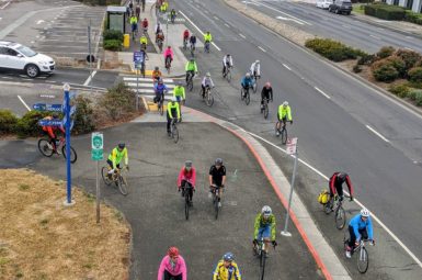
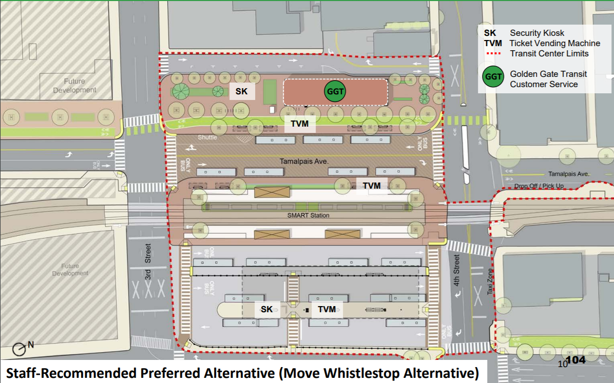
San Rafael Transit Center (San Rafael)
Location
Downtown San Rafael at the intersection of Fourth Street and Tamalpais Avenue.
Description
When the SMART Train was brought to Downtown San Rafael, the tracks and platforms needed to occupy a substantial portion of space formerly used for bus bays. This created a need to relocate and reimagine the transit center, a project that was kicked off in 2018.
Several options to relocate the transit center have been analyzed with respect to the transit rider experience, pedestrian/bike access, and impact on local traffic. The option preferred by Golden Gate Transit would relocate the Whistlestop building slightly to the north and consolidate the transit center on the block bound by Third Street/Hetherton Street/Fourth Street/Tamalpais Avenue.
This option is also favored by MCBC, as it provides the best access for bike riders and pedestrians. Additionally, it incorporates a two-way bike path on the west side of Tamalpais Avenue between Third and Fourth Street, which will be closed to private automobiles. This block would serve as a key link in the North/South Greenway, allowing through-riders easier access between the SMART path on both sides of Downtown San Rafael
Status
The Golden Gate Transit Board of Directors designed the “Move Whistlestop” option as the preferred alternative at its May 21st, 2021 meeting, allowing the project to proceed to develop the environmental impact report (EIR).
MCBC’s Role
We have been active in pushing for the “Move Whistlestop” alternative throughout the process, providing comment at meetings for the project at the San Rafael City Council and the Golden Gate Bridge District Board of Directors meeting.
We also have been pushing for the inclusion of an improved connection between 4th Street and 5th Street on W Tamalpais Avenue, which the current plan designates and taxi and Uber/Lyft pick-up space.
Estimated Completion Date
Unknown
Public Agency Website
https://www.goldengate.org/district/district-projects/san-rafael-transit-center/
Additional News
10/12/2016 – Vision for Safer Streets At San Rafael Transit Center
7/13/2018 – Join Us in Calling for a Walkable, Bikeable San Rafael Transit Center
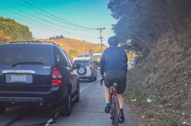
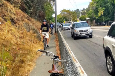
Richmond-San Rafael Connection Gap Closure (San Rafael)
Location
Francisco Boulevard E between the Grange Avenue and 580 Westbound on-ramp (where the current multi-use pathway ends).
Description
This project will close the gap between the existing multi-use path that extends from the western landing of the RSR Bridge Pathway to the new two-way bike path on the 580 flyover connecting to the intersection of Sir Francis Drake Boulevard and Andersen Drive (see yellow segment on the map).
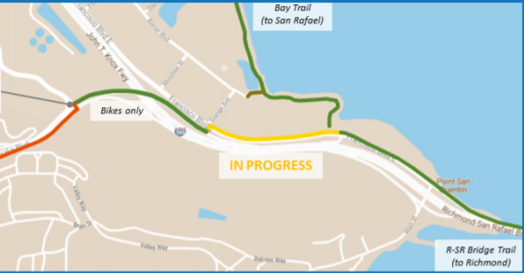
Currently the path only goes halfway between the bridge and the flyover, requiring riders to either ride on a narrow sidewalk or enter traffic. This project would allow riders to travel on a car-free separated pathway all the way from the bridge pathway to the intersection of Sir Francis Drake and Andersen Drive. A future project planned by the County will provide bike lanes or a separated pathway on Sir Francis Drake Boulevard from this intersection to Remillard Park, where the existing Bay Trail pathway ends.
Status
The project was funded by a grant from the Active Transportation Program and will be entering construction later this summer.
Estimated Completion Date
End of 2021
Public Agency Website
https://completestreets.mtc.ca.gov/projects/1114
Additional News
11/17/2020 – Building Safe Routes to the Richmond-San Rafael Bridge
E. Blithedale Avenue (Mill Valley)
Location
E. Blithedale Avenue between Camino Alto and Tower Drive/Kipling Drive (the 101 interchange)
Description
Mill Valley will be repaving this segment of road and, for the first time in the city’s history, it will include dedicated bike lanes. The project is planned to have separated bike lanes using paint and flexible posts. While MCBC does not believe the project goes far enough to physically separate riders from fast-moving cars, this represents a good first step that can be improved upon later.
In the eastbound direction (toward Tiburon) the bike lane will continue all the way from the Mill Valley-Sausalito Path to the 101 interchange. In the westbound direction, the bike lane will only go as far as the Chevron station at the intersection of Meadow Drive and Ashford Avenue, due to the narrow road. At that point riders can either use the new bike-only slip lane to travel west on Ashford to the multi-use path (the more pleasant but slower option) or continue on E. Blithedale using the 4’ shoulder (the faster option, but in close proximity to cars).
A future phase of the project will consider bike improvements to E. Blithedale Avenue west of Camino Alto and Downtown, but that phase is very early in the process and there have been no concepts put forward yet.
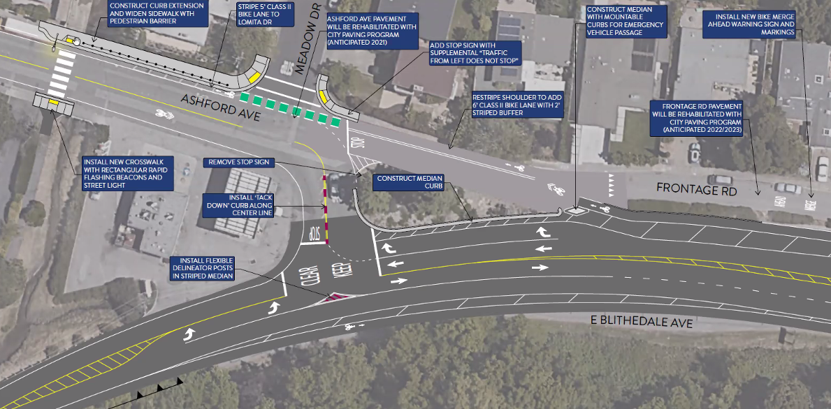
Connections to MUP
A small but helpful aspect of this project is an improved connection between E. Blithedale Avenue and the Mill Valley-Sausalito Path. Right now riders traveling east on E. Blithedale (perhaps coming from Camino Alto) must either get up onto the sidewalk at the Chase Bank parking lot or make a u-turn to get on to the pathway going south. The project will provide a ramp connecting E. Blithedale directly to the MUP.
Connection to US-101
While the project will provide bike lanes on E. Blithedale, they will not continue further east than Tower Drive/Kipling Drive and stop short of the US-101 interchange. This is because that roadway is owned by Caltrans rather than the City of Mill Valley. However, Caltrans is planning to do maintenance on that interchange in the next couple years, and MCBC will be pushing hard to ensure that that update will include a much improved bike experience.
Status
Funded and going to construction in Fall 2021.
Estimated Completion Date
Mid-2022
Public Agency Website
Additional News
3/10/2021 – Our Work Update on E. Blithedale Bike Lanes
5/21/2021 – Monday’s Mill Valley City Council Meeting Results in Mixed Bag for E. Blithedale
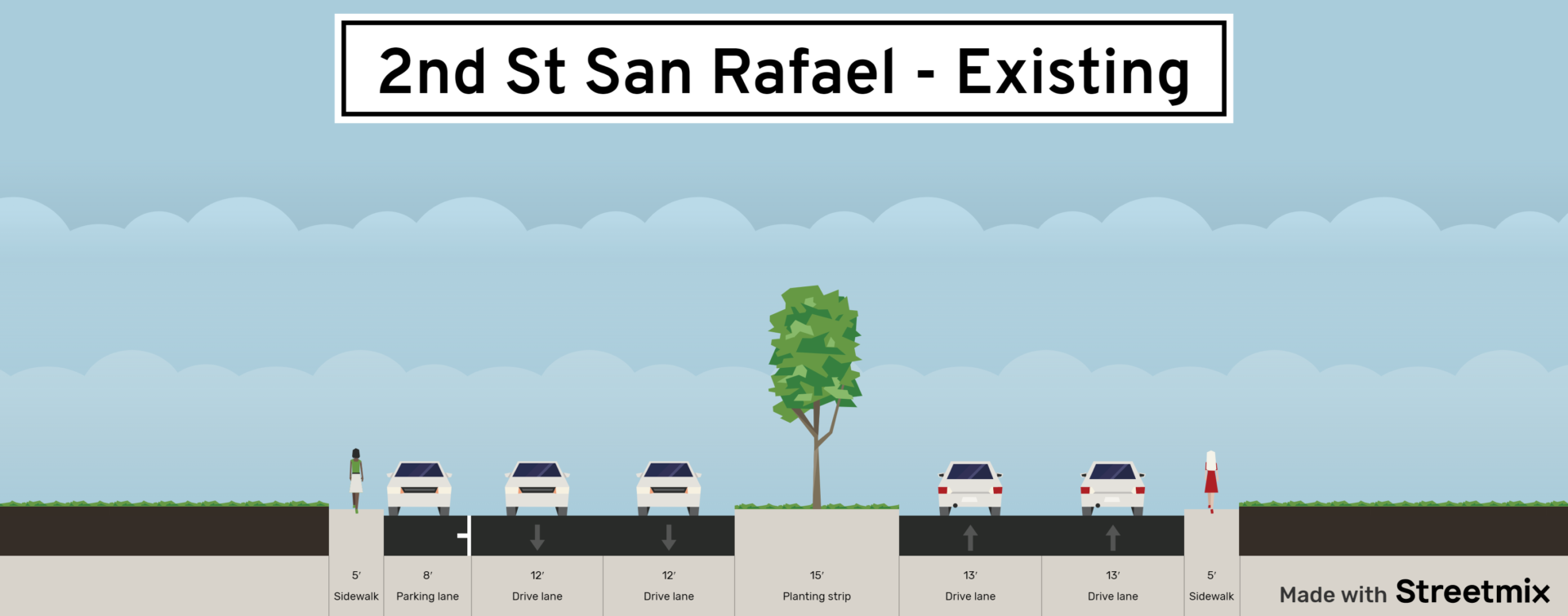
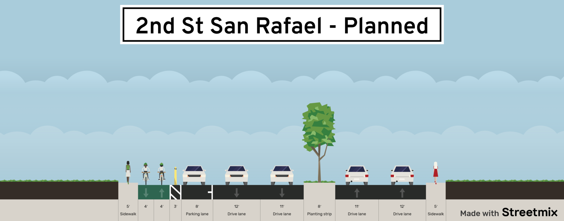
Second Street San Rafael Connector (San Rafael)
Location
Second Street between West Street and Shaver Street
Description
This project is part of the larger Third Street Rehabilitation Project, and will provide a two-way protected bikeway on the south side of the street. This is an important connection because there is currently no easy way to get between the Greenfield Avenue bicycle boulevard and the Gerstle Park neighborhood of San Rafael by bike.
Link to plans:
The project was initially planned to stop short of the (very challenging) intersection of Second Street/Fourth Street/West End Avenue. But, in response to feedback from MCBC and the San Rafael BPAC, the City decided to create an interim bike lane between West Street and Marquard Avenue, which will finish the connection to the Greenfield Avenue bicycle boulevard.
Interim Connection:
Status
The project was approved by San Rafael City Council at its May 3rd, 2021 meeting.
Estimated Completion Date
Construction will start September/October 2021 and will continue through Fall 2022.
Public Agency Website
https://www.cityofsanrafael.org/third-st-rehab/
Additional News
10/28/2020 – San Rafael Finalizing 2nd Street Protected Bikeway Design
08/11/2020 – Closing the 2nd Street Gap in West San Rafael
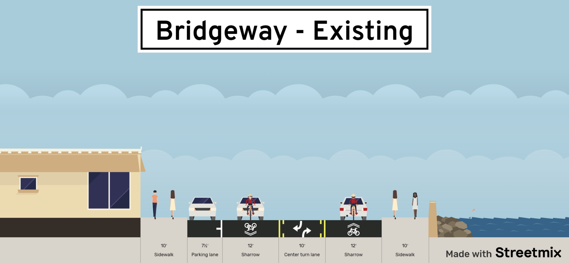
Bridgeway (Sausalito)
Location
Bridgeway in Sausalito between 2nd Street and Princess Street.
Description
This segment is one of the busiest bicycle corridors in the entire county, with commuter, recreational, and tourist traffic alike connecting riders between the Golden Gate Bridge and the rest of Marin. Despite this fact, there is no dedicated space for bicycle riders, with only Class 3 shared lane markings.
Advocates have asked the City to reallocate roadway space from the little-needed two-way center turn lane to permit dedicated bike lanes in both directions. This would be a win-win project, reducing the frequency of close-passes for bicyclists while allowing drivers to travel in a separate lane from bicyclists.
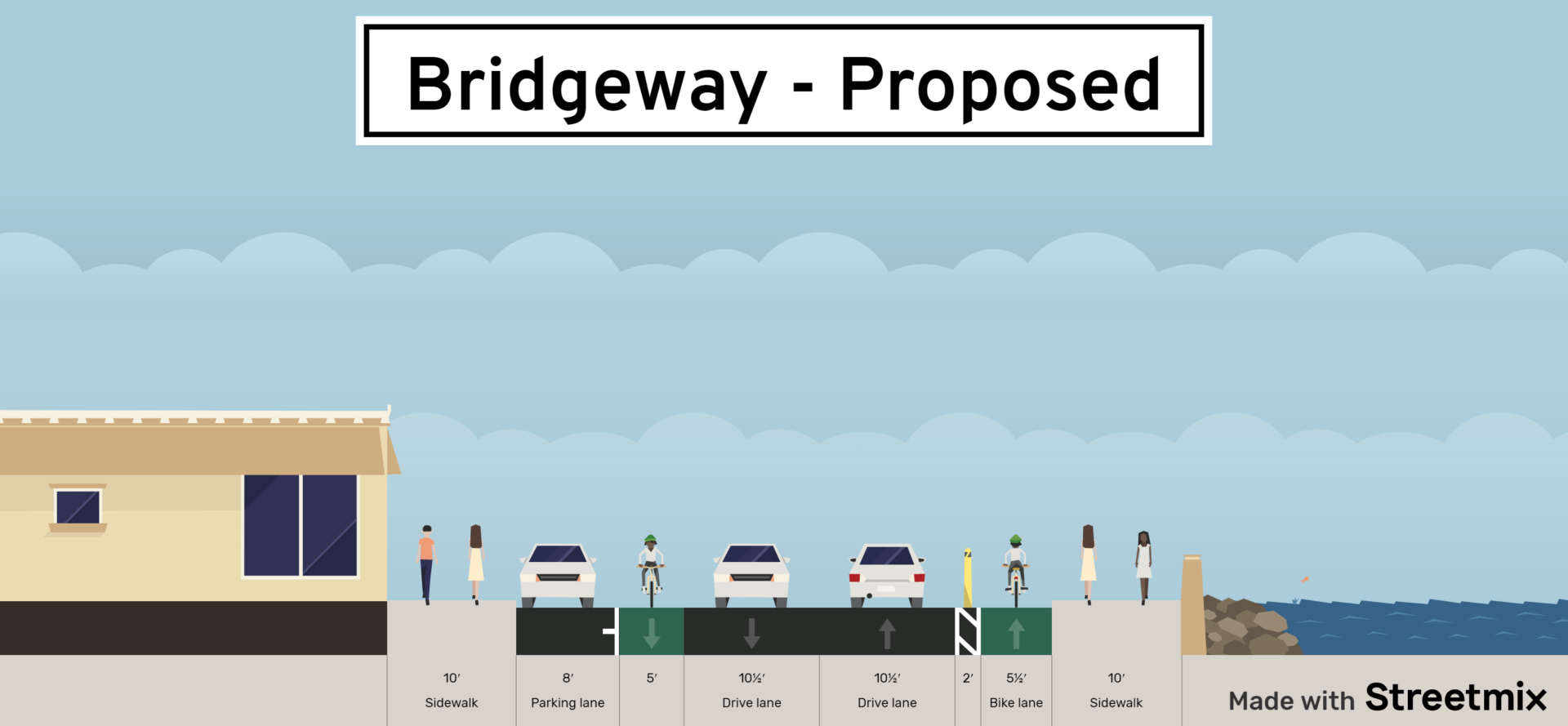
Status
The City of Sausalito received a grant from the San Francisco Bay Trail to fund design for this segment, which is underway now.
Estimated Completion Date
Unknown. After design is completed, the City will likely need to win grant funding for construction.
Public Agency Website
No website yet.
Additional News
11/29/2018 – Calling for a Better Bridgeway | MCBC
Corte Madera Creek Crossing
Location
East side of US-101 crossing Corte Madera Creek between the Larkspur Ferry Terminal and Redwood Highway in front of Bevmo and Trader Joe’s.
Description
The current crossing of the creek is an inadequate 4’ sidewalk, barely wide enough to ride a bike on one-way, much less pass someone coming the other way.
This project will construct a new structure on the east side of the existing bridge, providing a wide pathway for both pedestrians and bicycle users.

Status
The project is under construction now.
Estimated Completion Date
Completion of the project is expected sometime in early 2022.
Public Agency Website
NS Greenway Northern Segment — North-South Greenway Gap Closure Project
Additional News
7/9/2020 – Widened Bike/Ped Pathway Over Corte Madera Creek To Begin Construction in 2020
Thanks for taking the time to read this piece. As always, if you want more information or would like to get involved in any of these projects, please feel free to email warren@www.marinbike.org.
sign-up for advocacy alerts
We will need your help winning these improvements! Please sign-up for advocacy alerts using the form below and we’ll tell you when/how to support our efforts.
members make it happen
We’re working to make Marin more bike-friendly for people of all ages and abilities. Are you with us?