news Reimagining a Resilient SR 37
State Route 37 has long been a sort of no-go zone for bicyclists. While it serves as the most direct route between Novato in Marin County and Vallejo in Solano County (via Sears Point), it’s attempted by only the most risk-tolerant riders or those with no alternative means of transportation. There is no transit service between the two counties. A 30-minute drive is either a 3-hour multi-transfer bus/train ride, or a very scary 90 minutes of riding on a busy highway shoulder.
And the road’s challenges are not limited to bike riders. Due to its low-lying nature and sea level rise, the already-frequent flooding will only increase in the future. As anyone who commutes on this road knows, it sees significant congestion due to the large number of people who live in Solano County and work in Marin.
However, this could all change. There are several planning efforts in the works to address the current and future challenges on SR-37, which we will outline below.
The near-term efforts divide the corridor into two segments: Novato to Sears Point (US-101 to SR-121) and Sears Point to Mare Island (just west of Vallejo). The long-term project includes the whole corridor. Though it’s going to be a while before the corridor becomes usable for bikers and pedestrians, we need your help now to make sure that happens.
Near-Term Projects
Construction in 2027 – Novato to Sears Point – Sea Level Rise Adaptation
The segment of SR-37 between Novato and SR-121 at Sears Point is subject to seasonal flooding in several spots. Caltrans plans to modify waterway crossings in an attempt to reduce the frequency of flood closures.
The project is not planned to improve the biking experience on the road, but should not degrade it from its current (very bad) state.
There are no meetings currently planned, but readers should expect one this spring or summer, when the Draft Environmental Impact Report is released.
The current fact sheet can be found here.
Construction in 2025-26 – Sears Point to Mare Island – Highway Widening
While the western segment of SR-37 is four lanes wide, this segment is only two lanes wide. Because of the high demand on the corridor (namely, people employed in Marin who live outside the county), the road sees significant traffic jams, particularly in the afternoon commute heading eastbound. To increase total capacity on the highway, Caltrans is planning to widen this segment.
There are several alternatives still under consideration, including a moveable center lane (as on the Golden Gate Bridge, peak-hour-only lanes (as on the Richmond-San Rafael Bridge lower deck), and making the road four lanes full time.
None of these options contemplate improving bicycle access on this route, and some would make the bad situation even worse, narrowing the ~10’ shoulder to 4’.
We should note that, despite claims for the better part of a century, widening roads does not fix congestion. When a jammed road is widened, new drivers show up to fill it, reducing any travel time gains. The only things that reduce congestion are (1) letting people live closer to the places they are driving to and (2) pricing the road to encourage carpooling and traveling at off-peak times. Happily, it appears that tolling is being proposed.
A meeting for this project will be held on Wednesday, February 2nd at 5:30 PM. Click here to join the meeting.
An official factsheet for the project can be found here.
Long-Term Project
The long-term vision of the SR-37 corridor is the subject of what is called a Planning and Environmental Linkage (PEL) study. This study will determine the best plan for the corridor in a future of rising seas and less single-occupant car travel.
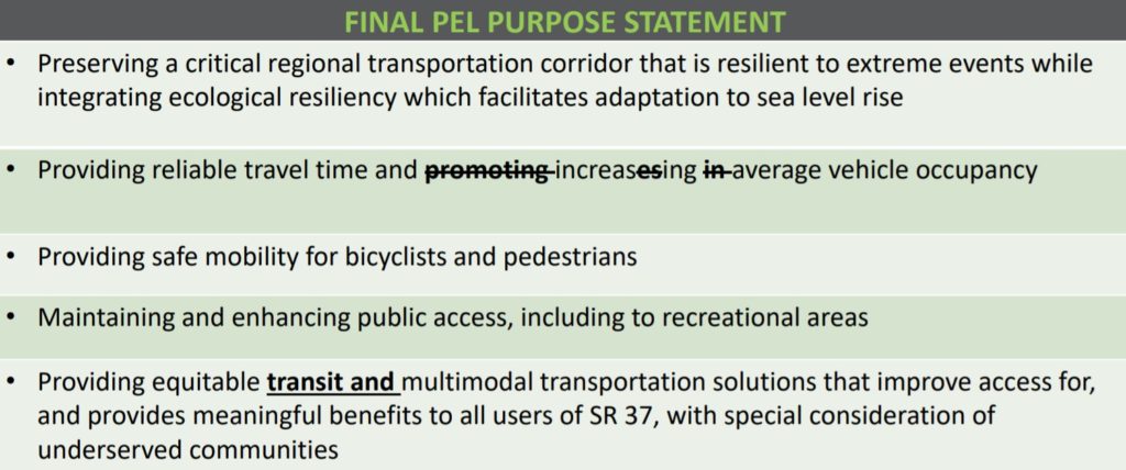
The project has thus far developed a series of goals that will guide the rest of the project, shown below. Importantly, providing bicycle and pedestrian access is one the primary purposes, something that MCBC has supported throughout the process.
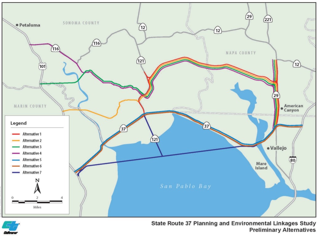
Because of the threat posed to the highway by sea level rise, several alternate alignments (i.e. ways of routing the road) have been proposed. Each of these has pluses and minuses, mostly with respect to directness, cost, and environmental impact. The alignments have been narrowed down somewhat, but there is still analysis that has to be performed to decide which is best.
The chosen alignment will partially determine the form that SR-37 takes, whether an elevated causeway on an embankment. Under either alternative, it is MCBC’s firm stance that a fully separated shared use path be constructed to provide car-free access along the highway and to the various wetlands and wildlife refuges.
A public project update was held Tuesday, January 25th. This meeting explained the above in more detail, and provided attendees with a chance to ask questions or provide comments on the work thus far. You can find the presentation and a recording of the meeting here. And you can still use our email template to communicate directly to the project team.
sign-up for advocacy alerts
Please sign-up for advocacy alerts using the form below and we’ll tell you when/how to support our efforts.
members make it happen
We’re working to make Marin more bike-friendly for people of all ages and abilities. Are you with us?
