Call for New Trail, Pathway Connections Bicycling Access on Our Public Lands in Pt. Reyes National Seashore
UPDATE 8-25-19: The Draft Plan is available for review and comment now through September 23 at https://parkplanning.nps.gov/poregmpa
Pt. Reyes National Seashore is one of Marin’s greatest natural assets. But for far too long, access in the National Park has been severely limited. As NPS begins its review of leased land management practices, join MCBC in calling for improved bike access to our public lands by commenting before November 30.
NPS recently initiated a process that will guide future management practices of the approximately 28,000 acres of non-wilderness areas it owns and leases for agricultural use. This is a unique opportunity to create better connectivity, safety, and visitor experiences for all cyclists, whether they’re on road, gravel, or mountain bikes.
Please take a minute to echo MCBC’s priorities by voicing your support for the following projects through the NPS website:
-
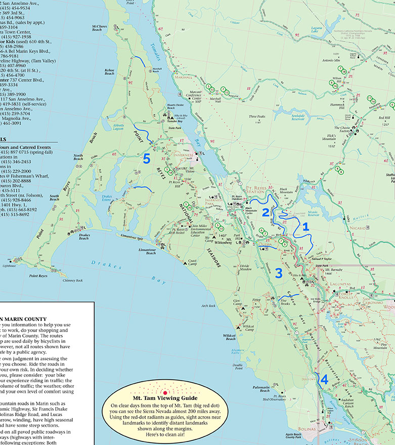
A new trail between Devil’s Gulch and Platform Bridge through the Cheda, McIsaac, and Zanardi Ranches.
-
A plan to connect the Cross Marin Trail into Point Reyes.
-
Adoption of social trails off Bolinas Ridge for better connectivity and a single-track trail experience.
-
Extend the Olema Valley Trail to Bolinas on the east side of Highway 1.
-
Close gaps for bikes through ranch lands in the park, including closing the Estero Trail loop, connecting Sir Francis Drake Blvd. with Pierce Point Road, and connecting Marshall Beach to Pierce Point Road,
-
A more bike-friendly permit application process for road and mountain bike events in the park, including along Bolinas Ridge and out to the lighthouse.
-
Bike access to all ranch roads in the pastoral zone that are already open to pedestrians.
CLICK HERE TO SUBMIT COMMENTS BY NOVEMBER 30
For more information and to comment by November 30, visit the project website.
