Our Work Building Safe Routes to the Richmond-San Rafael Bridge
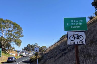
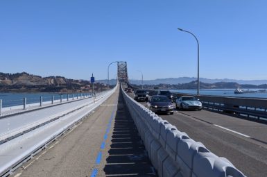
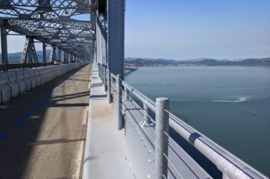
Bike the Bridge! After decades of advocacy from Marin County Bicycle Coalition, Bike East Bay, and SF Bay Trail, the Richmond-San Rafael Bridge multi-use pathway is open! Head to our Richmond-San Rafael Bridge resource page for all things bridge-related, including route planning, news, and more!
One down, two to go! Since the Richmond-San Rafael Bridge multi-use pathway opened in November 2019, we’ve been doubling down for safer, more intuitive connections to and from the bridge. Find out what we’re working on following the recent completion of a protected bikeway linking Francisco Blvd. E with Andersen Drive.
one down: two-way protected bikeway linking andersen drive with francisco blvd. east

Installation of a barrier dividing the travel lane from the shoulder enables people to ride in both directions on the westbound Sir Francis Drake Blvd. off-ramp between Andersen/SFD and Francisco Blvd. E.
Bay Area Toll Authority–with funding from Transportation Authority of Marin–recently completed installation of a two-way barrier-protected bikeway linking Francisco Blvd. E with Andersen Drive. Of the bicycling gaps near the Richmond-San Rafael Bridge, this was our highest priority because it 1) gives people bicycling eastbound a safe alternative to the I-580 shoulder, 2) keeps people coming from Andersen Drive from having to cross two directions of high-speed traffic on Sir Francis Drake Blvd., and 3) protects people riding westbound from high speed traffic on the Sir Francis Drake off-ramp.
Of note, the improvements also include a new access point at the intersection of Francisco Blvd. E and Grange Avenue that will be much easier to see and access for those riding westbound.
With the barrier is in place, the safest route to the bridge for most will be via Andersen Drive (accessed via Cal Park Hill Tunnel for those coming from Larkspur). Those who choose to ride from Larkspur via Sir Francis Drake Blvd. should not attempt to cross at the Andersen/SFD intersection to access the bikeway due to high vehicle speeds and poor sightlines. If you’re riding eastbound on Sir Francis Drake, we strongly recommend continuing on the I-580 eastbound on-ramp shoulder.
Two to Go…

This map highlights the two remaining gaps that hamper R-SR Bridge access, especially for less-experienced cyclists. Information about each of the gaps and what we’re doing to fill them is provided below. Click to enlarge.
multi-use pathway from r-sr bridge to grange Avenue (In Progress)

Completion of a multi-use pathway along Francisco Blvd. E (shown above) is delayed indefinitely due to a sharp decline in bridge toll revenue during the Shelter in Place Order.
BATA’s construction of a multi-use pathway along Francisco Blvd. E (shown above and on the map in yellow) between the bridge and Grange Ave.–where it would connect with the new protected bikeway described above–is still delayed indefinitely due to a sharp decline in bridge toll revenue during the pandemic. The $5m pathway was originally slated for construction this year.
MCBC supported an Active Transportation Program grant application for this project, with awards expected to be announced sometime in spring 2021. Given the funding uncertainty, we have encouraged the City of San Rafael and BATA to collaborate on possible quick-build improvements to Francisco Blvd. E in order to create a better interim connection.
multi-use pathway from larkspur to andersen/sfd (advocacy needed)

The Bay Trail currently ends at Remillard Park in Larkspur, leaving a .7 mile gap to the protected bikeway at Andersen Dr./SFD Blvd.
The County of Marin completed a study in 2011 analyzing bicycle and pedestrian connectivity in the San Quentin area, which included conceptual designs and cost estimates for completion of the Bay Trail between its existing terminus at Remillard Park in Larkspur and the Richmond-San Rafael Bridge. With the two projects above complete and underway, we are honing in on the final Bay Trail gap in this area, which would run along the southern edge of Sir Francis Drake Boulevard between Remillard Park and the Andersen Drive intersection (shown above in red).
MCBC teamed up with Bay Trail and Rails-to-Trails Conservancy in September to ask the County to update the cost estimates and scope of work for the remaining .7 mile Bay Trail gap. We learned last week that they plan to do so in the coming weeks, an important first step toward understanding what’s needed to move the project forward.
Sign-up for Advocacy alerts
If you would like to get involved in our efforts to win better routes to and from the bridge, please share your information below.
members make it happen
All of our work to make bicycling in Marin safe, fun, and accessible relies on your generous giving. Please support your bicycle coalition by making a one-time or recurring gift today!