Fixing San Rafael San Rafael Adopts Ambitious Vision for Bicycling
In a huge win for MCBC and anyone who walks and bikes in Marin, San Rafael’s City Council recently adopted a Bicycle and Pedestrian Master Plan highlighted by our vision for a safe, connected bike network that aims to make bicycling an option for people of all ages and abilities.
There’s no place in Marin with greater bicycling needs – or potential – than San Rafael. From the outset of the planning process, we’ve been focused on identifying seamless bike routes that should provide dedicated space for people on bikes. Whether you’re a daily commuter or parent of a child who bikes to school, there’s something in this plan for you.
MCBC’s highest priority areas – Downtown and the Canal District – are areas in which bicycle connections are almost non-existent, forcing people on bikes to ride on sidewalks or share roadways with fast-moving traffic.
“Many people in San Rafael are interested in bicycling more regularly, but too concerned for their safety to do so,” said Bjorn Griepenburg, MCBC’s Policy & Planning Director.
“Busy streets without separated or protected bike lanes, like Fourth Street or Bellam Boulevard, are a major deterrent to biking. This plan’s acknowledgement that people need physical separation from traffic is a major milestone, especially in San Rafael.”
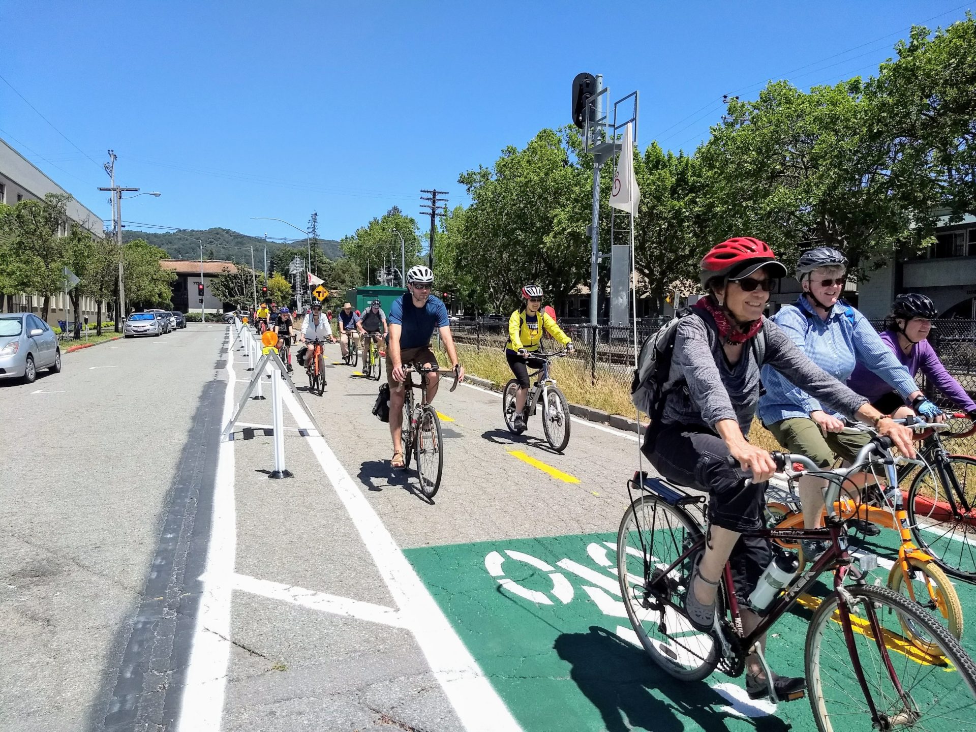
Protected bike lanes: coming to a San Rafael street near you? Image credit: havefunbiking.org
Thanks in large part to MCBC’s early involvement, this plan is the first in Marin to establish a vision for a network of bicycle routes that places emphasis on separation from traffic. Where bike routes run along busy, high-traffic roads, protected bike lanes are recommended. Shared lanes are recommended only on quiet neighborhood streets with low traffic volumes and speeds.
Plan Highlights
Our highest priority projects form what we originally presented to stakeholder groups as the “minimum grid” concept, shown in the map below. The minimum grid establishes a starting point for San Rafael’s bike network, with emphasis placed on regional connectivity. We were pleased to see these bikeways included in the plan as priorities.
Key projects from the minimum grid are described below:
East-West Downtown Route
Why it Matters: There isn’t a single inch of asphalt dedicated to moving bikes between the east and west through San Rafael’s downtown.
Highlights:
– Improvements to the 4th St/2nd St./West End intersection to facilitate safe and convenient crossings for those travelling between downtown and West End.
– A commitment to study the feasibility of (or pilot) protected bike lanes through downtown, presumably on 4th or 5th.
Cross-Marin Bikeway
Why it Matters: There’s no safe, convenient route for those traveling between San Anselmo/west San Rafael and Cal Park Hill Tunnel. The route itself has been studied, but was not included in San Rafael’s last Bicycle and Pedestrian Master Plan.
Highlights:
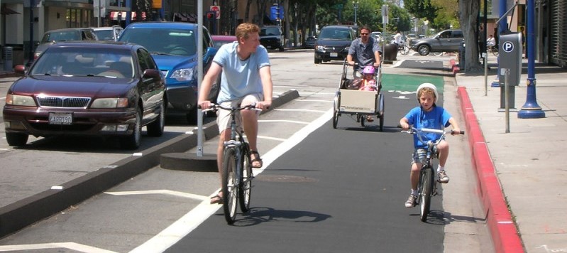
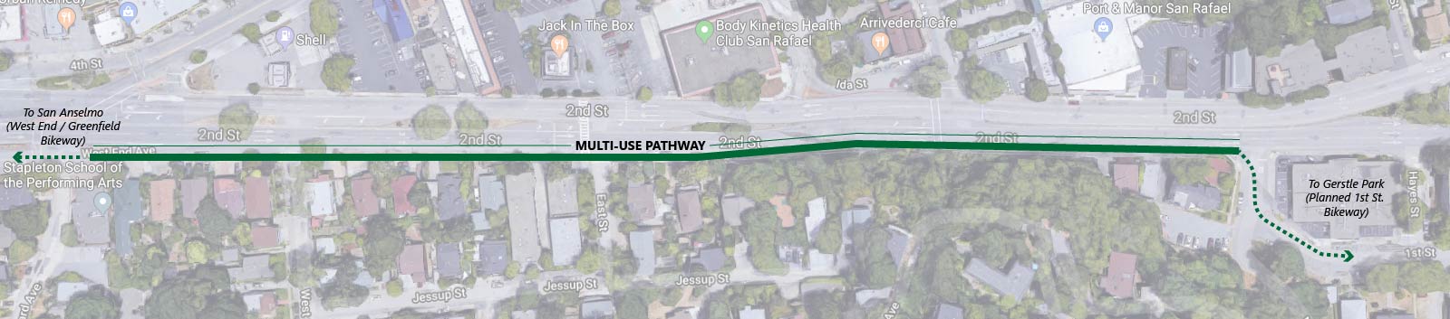
– A multi-use path along the dangerous stretch of 2nd St. between West End Ave. and Miramar Ave.
– Minor treatments to form a low-stress connection through neighborhood side streets south of 2nd St.
– A multi-use pathway near the San Rafael Community Center and Albert Park connecting B St. to Andersen Drive.
– Better connectivity between Mahon Creek pathway and Andersen Drive.
North-South Greenway
Why it Matters: The stretches of Tamalpais Ave. and Hetherton St. between 2nd St. and Mission Ave. connect the North-South Greenway through downtown. The low-stress experience of riding on the North-South Greenway should not be compromised by this short on-street connection.
Highlights:
– Making the busy 2nd St./Tamalpais Ave. intersection easy to navigate for those traveling between downtown and the Mahon Creek or 2nd to Andersen pathways.
– Creating a low-stress route along Tamalpais Ave. to connect the Mahon Creek and 2nd to Andersen pathways with the Puerto Suello Hill Pathway.
Canal Connections
Why it Matters: The Canal neighborhood is incredibly isolated by water and freeways, with just two street connections to the rest of the City (via Francisco Blvd. West/Grand Ave. and Bellam Blvd.), both of which are dangerous and uninviting.
Highlights:
– Protected bike lanes on Grand Ave. connecting to the proposed east-west route on 4th St.
– Protected bike lanes on Bellam Blvd. connecting to the North-South Greenway.
– A commitment to study the feasibility of a more direct Canal crossing in order to keep those travelling between the Canal and Downtown/Montecito area from having to use Francisco Blvd. West.
Next Steps
These plans mean very little if the projects within them do not become a reality. MCBC is eager to begin – or in some cases, continue – working on several high priority projects recognized in the plan:
– A new multi-use pathway along the dangerous stretch of 2nd St. between West End Ave. and Miramar Ave. as part of the Third Street Rehabilitation Project (shown above).
– Protected bike lanes on Bellam Boulevard as part of an upcoming street repaving project.
– Permanent improvements to Tamalpais Avenue as part of, or in advance of, the San Rafael Transit Center Project.
– East-west improvements through Downtown San Rafael.
Help support MCBC’s ongoing work to make San Rafael a safe place to walk and bike by joining or giving below!